

The Struggle for Democracy
Edward S. Greenberg | Benjamin L. Page | David Doherty | Scott L. Minkoff | Joshua M. Ryan
The Struggle for Democracy is an introductory American Politics textbook that offers students the tools they need to critically analyze the American political system and make judgments about how well our government works. Taking a fresh approach to common American government topics, authors Edward Greenberg, Benjamin Page, David Doherty, Scott Minkoff, and Joshua Ryan provide an analytical framework for understanding how politics and government work and encourage students to continually consider the question “How democratic are we?”. In order to boost student engagement with key concepts, the 2022 Midterm Election Edition incorporates coverage of contemporary issues that dominate today’s headlines, as well as the most up-to-date data.
The online edition of the book uses Pearson's state-of-the-art textbook platform Revel. Features of Revel include:
-
Up-to-date interactive graphs, maps, and figures
-
Current events bulletins in each chapter to helps students stay up to date with what is going on
-
Multiple choice quiz questions after each chapter section (that connect with your course management software)
-
The ability to track student reading times
-
Lecture launchers for each chapter that help instructors to introduce class sections that connect current events directly with the text.
More details and adoption information can be found here. You can also feel free to contact me with any adoption questions at sminkoff@gmail.com.
Research
Vote by Mail: When voters evaluate vote-by-mail (VBM) policies, do they make a single judgment about desirability or weigh multiple independent considerations? This study analyzes a survey of 2,000 voters in permanent absentee voting states to examine how attitudes toward vote-by-mail operate along three distinct dimensions: access benefits, implementation concerns, and myth beliefs. The analysis reveals that these dimensions relate to each other differently across racial groups in ways that reflect differential experiences with electoral institutions. Black voters demonstrate more dimensional independence while White and Hispanic voters demonstrate more dimensional integration. Notably, for Black voters, historical and contemporary experiences with institutional discrimination create rational separation between benefit and concern/myth evaluations. The analysis simultaneously shows that it is belief in the benefits of VBM that is the primary driver of attitude formation about optimal mail voting policy. The findings have important implications for electoral reform advocacy: benefits can drive policy support even when concerns remain high, suggesting that emphasizing access benefits can build support without first eliminating all implementation skepticism.
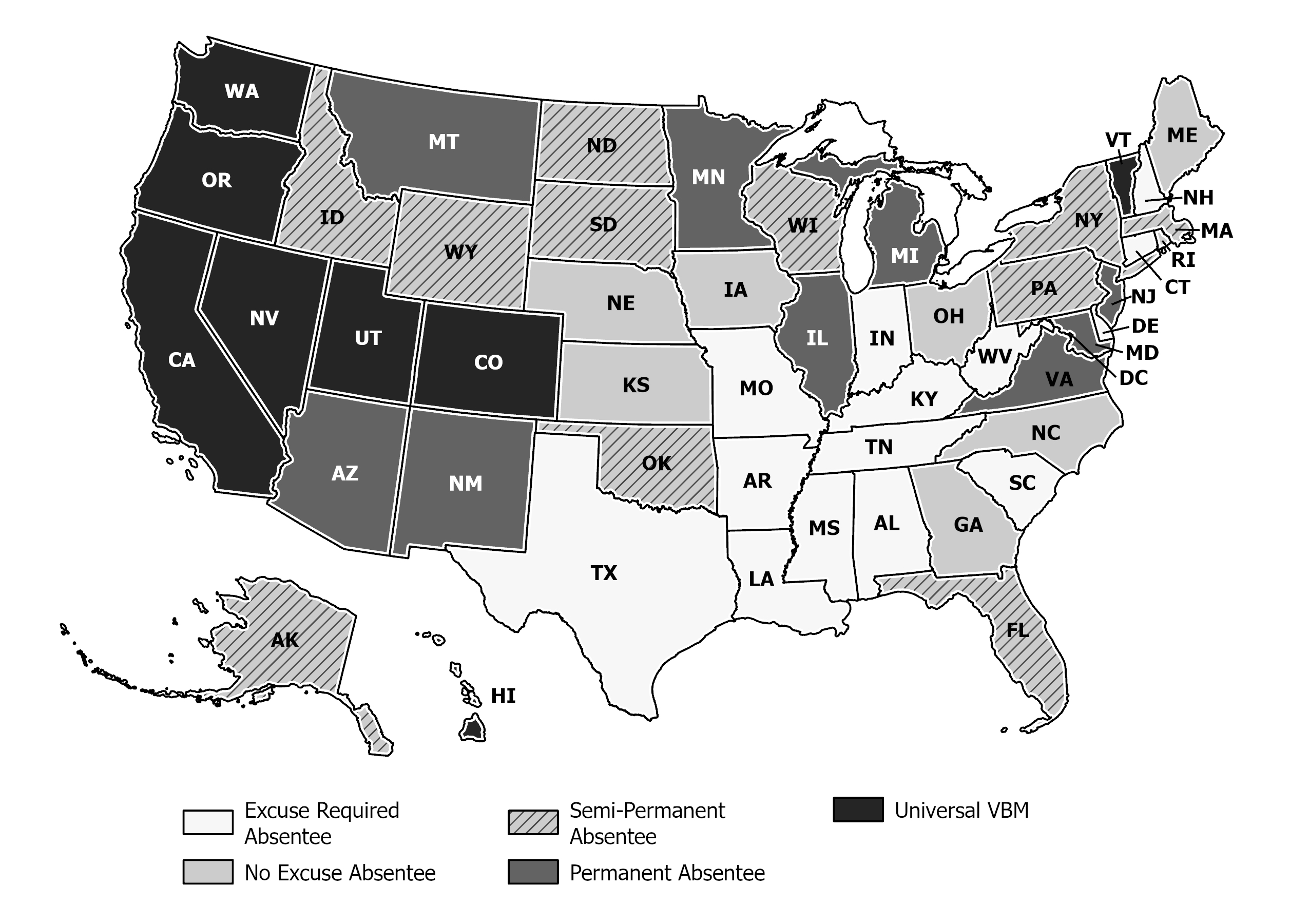
2024 State Vote By Mail Policies

Billboard Voter Mobilization: This research presents the design and results of a voter mobilization field-experiment conducted during the 2019 election in conjunction with Vote.org. To test the effect of non-partisan voter mobilization billboards fitted with Election Day information, maps of study areas in four states were overlaid with a grid (or “fishnet”) containing 3-mile by 3-mile cells. Cells were randomly selected to be in the treatment or control group. All available billboards in the treatment cells that met certain criteria were purchased and fitted with a reminder to vote. Across the four states, 207 billboards were treated and 142 served as control billboards for the weeks leading up to Election Day. Results indicated that registered voters living in treated cells had a probability of voting that was higher than those living in control cells. The effect size was similar in magnitude to comparable mobilization treatments and was strongest among mid-propensity voters. (Link to Paper)
Living with Inequality: Income inequality has risen steadily in recent decades, yet Americans’ political attitudes and perceptions of economic factors do not appear to have changed in response. This raises the question of what drives perceptions and attitudes about inequality? Jeff Lyons and I are exploring whether the places where people live – and specifically the diversity of incomes where people live – influence views about inequality. Using my unique geo-coded survey of New York City, we find consistent evidence that attitudes about inequality are influenced by the places where we live – those who are exposed to more income diversity in their place of residence perceive larger gaps between the rich and everybody else and are more likely to believe that the gap should be smaller. However, these contextual effects appear to be conditional upon racial distributions – as the percentage of non-whites increases, contextual income diversity more weakly informs the attitudes of whites. This work has recently been publish in American Politics Research. (Link to Paper)


NYC 311: 311 is a telephone and web service that allows residents of many cities to report nonemergency concerns and problems with city services to their local government. This article explores the Census-tract-level variation in 311 contacting volume within New York City. Drawing on previous research on citizen–government interaction, service delivery, and civic engagement, the article focuses on how contacting propensity and condition both explain spatial variations in contacting volume. These explanations are tested using indicators that describe the people who live and work in the space, the housing in the space, the economic development of the space, and the space’s representation in city government. 311 contacting is divided into three categories (government-provided goods, graffiti, and noise) that are separately analyzed using regression models that account for spatial and serial dependence. The article also discusses the theoretical and methodological challenges of using 311 data to understand the distribution of problems within a city. (Link to Paper)
The Proximate Polity: People have the power to change where they live, where they work, where they vote, and where they spend their money. This geographic uncertainty has important implications for the policies cities pursue as it impacts the relative value of local goods provision. In this dissertation I examine how the potential movement of people within metropolitan areas influences developmental goods provision and production.
The proximate polity theory begins with the assumption that city officials aim to maximize the economic and political benefits of developmental policies while also minimizing the economic and political risks of policy failure. Accordingly, local leaders strike this balance by anticipating how their policy choices are likely to influence the movement of people in and out of the jurisdiction. In order to make this assessment, public officials must be keenly aware of who resides in nearby cities and also which policies nearby cities are engaging. Because policy consequences do not end at the jurisdiction’s edge, leaders must also pay attention to how their policies will influence the political relationships that exist between themselves and other cities.
Using spatial statistics and network analysis tools, I test the theory on a dataset of 15 metropolitan areas across the United States. I then focus in Colorado’s Front Range cities for a closer analysis that includes original survey data, time-space models of development policy over a 25 year period, and a dyadic analysis of intergovernmental developmental cooperation.
Papers from this Project: The Proximate Polity (UAR), From Competition to Cooperation (APR)


